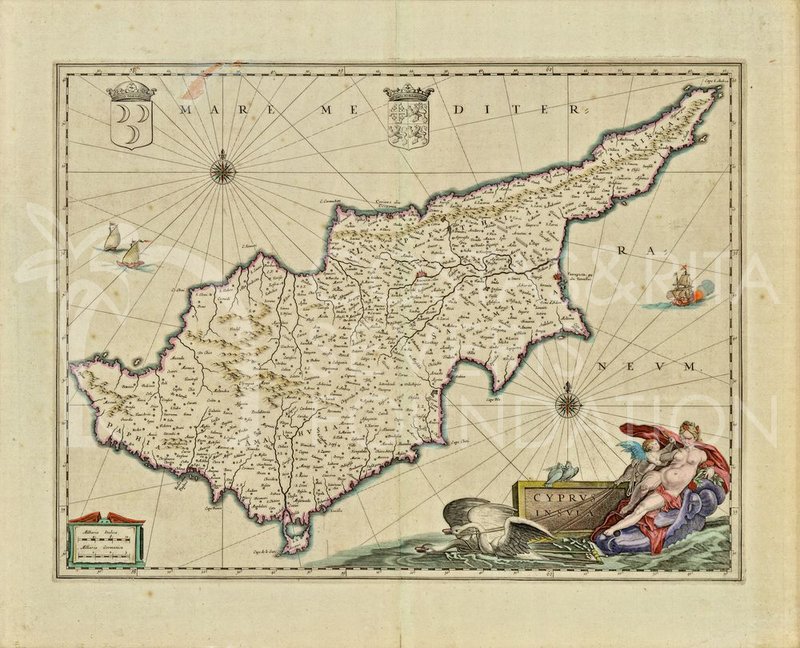
Inscribed: MARE MEDITERRANEVM /CYPRUS INSVLA
This map of Cyprus is based on the Ortelius map of 1573. The main difference lies in the artistic cartouche of Venus and two Coats of Arms. The first one is the Coat of Arms of the Royal House of the Lusignan's and the second is that of Turkish Arms.
In the decorative cartouche on the right-hand corner, Venus or Aphrodite is depicted lying within a shell drawn by two swans towards Paphos. A putto represents the God of Love, Eros, pricking Aphrodite’s breast with his arrow.
Just behind the figures, a stone with the inscription CYPRUS INSULA can be seen.
Two white doves, the sacred birds traditionally associated with Aphrodite and love, sit on the stone.
The map with this cartouche attests to the fact that Cyprus’s association with Aphrodite as her birthplace continued throughout the Middle Ages. This mythological link always attracted travellers to the island.
Willem Janszoon Blaeu (1571-1638) was a Dutch cartographer, atlas maker, and publisher. Along with his son Johannes Blaeu, Willem is considered one of the notable figures of the Netherlandish or Dutch school of cartography during its golden age in the 16th and 17th centuries.
The son of a herring merchant, Willem Janszoon Blaeu went to the island of Ven to study under the noted astronomer Tycho Brahe (1546-1601).
Blaeu returned to Amsterdam and established himself as a successful printer, cartographer, globemaker, and instrument maker. He applied his astronomical training to more accurately measure the circumference of the Earth and wrote books aimed at improving navigation. Towards the end of his life, he was the official cartographer of the powerful Dutch East India Company. Beyond the fields of cartography and astronomy, he additionally invented the “Dutch press,” a modified version of the printing press that included a counterweight to allow the platen to rise automatically. It remained in use until the cast-iron press invented by Charles Stanhope in the early 1800s.
Joan Blaeu (1596-1673) was a Dutch cartographer and the official cartographer of the Dutch East India Company. Blaeu is most notable for his map published in 1648, which was the first map to incorporate the heliocentric theory into a map of the world and was the first map that incorporated the discoveries of Abel Tasman. Blaeu renamed what is now New Zealand as Nieuw Zeeland after the Dutch province of Zeeland; the anglicized version of the name is still in use today.
PNT-00059 > Willem Janszoon Blaeu (1571-1638), Joan Blaeu (1596-1673), Cyprus Insula, Engraving (coloured), 50x60 cm, 1635
The 'Sneak Peek' series is supported by The Hellenic Initiative Canada.


